Portrait of Tlili Mohamed, GIS Engineer
CV Icon
Curriculum Vitae PDF • EN
Download

GIS Engineer

I design reliable spatial data systems, automate GIS workflows, and deliver accurate geospatial products with ArcGIS Pro, QGIS, Python, SQL Server, Smallworld GIS, and LiDAR tools.

Open to: GIS Engineer · GIS Developer · Geospatial Data Engineer · GIS Automation · LiDAR/GIS Analyst
Professional Focus

I am targeting full-time roles where spatial data must be structured, automated, and trusted — in teams that treat GIS as core infrastructure.

Roles I am targeting

GIS Engineer
GIS Developer
Geospatial Data Engineer
GIS Automation Specialist
LiDAR / GIS Analyst

Work environments

Municipalities & public utilities
Engineering & surveying firms
Telecom & fiber network operators
Mining & exploration teams

How I work

Schema-first data modeling
Automate the repetitive
Validate before delivery
Reusable Python tooling

Featured Projects

Four production projects that show how I design spatial databases, automate GIS workflows, and deliver validated geospatial products.

Geodatabase feature classes and schema design in ArcGIS Pro
Database Architecture

Design and Integration of a Geodatabase

I designed and built a centralized municipal geodatabase on SQL Server that turned fragmented legacy data into a validated, multi-user spatial data system.

ArcGIS Pro | SQL Server | Python | Arcade | Versioned Editing

90% fewer data-entry errors ~100 feature classes designed 10+ yrs legacy data migrated

Snapshot

  • My role: I designed the schema, led implementation, and built the automation and validation layer.
  • Context: Municipality running a multi-department GIS program (client details withheld).
  • Scale: ~100 feature classes, 10+ years of legacy records, multi-user editing.
  • Technologies: ArcGIS Pro, SQL Server, Python, Arcade.

Challenge

Several departments needed one centralized GIS database instead of disconnected files. The system had to model complex data relationships, enforce validation at entry, and support multi-user editing with proper conflict management.

Technical approach

  • I designed a normalized geodatabase schema of approximately 100 feature classes from custom data dictionaries.
  • I implemented coded domains so invalid values are blocked at entry, not discovered downstream.
  • I created Arcade attribute rules that automate validation and calculated attributes in real time.
  • I developed a Python toolbox for ETL and the migration of 10+ years of legacy data into SQL Server.
  • I built versioned editing workflows with conflict resolution for simultaneous multi-user work.

Deliverables & validation

  • Enterprise geodatabase in SQL Server, Python migration toolbox, and attribute-rule documentation for each department.
  • Every migration batch was reconciled against source records to confirm zero feature loss before sign-off.

Results

  • 90% fewer data-entry errors after validation rules were enforced
  • 10+ years of legacy data migrated without loss
  • Departments now edit one shared database instead of separate files
  • Automated routines save hours of manual work every day

Why it transfers

Any organization that needs to trust its spatial data needs this exact pattern: a designed schema, enforced validation, and automated migration. I can apply it to utilities, networks, or environmental datasets from day one.

Classified LiDAR point cloud and elevation model
LiDAR Processing

LiDAR Classification with MicroStation

I processed multi-mission aerial LiDAR point clouds into consistently classified datasets and delivered high-resolution DTM and DSM products.

MicroStation | TerraScan | Python (laspy) | Automation

~95% classification accuracy in checks ~15% faster processing DTM/DSM delivery

Snapshot

  • My role: I built and ran the classification pipeline, from preprocessing to final DTM/DSM delivery.
  • Context: Production LiDAR processing for survey deliverables across several flight missions.
  • Scale: Multiple flight missions, heterogeneous point densities, ground / vegetation / building classes.
  • Technologies: MicroStation, TerraScan, Python (laspy).

Challenge

Raw point clouds arrived from several flight missions with different point densities and inconsistent pre-assigned classifications — making reliable terrain modeling impossible until the data was standardized.

Technical approach

  • I developed MicroStation macros to automate preprocessing and cleaning of incoming point clouds.
  • I implemented custom classification routines in TerraScan to standardize ground, vegetation, and building classes across all missions.
  • I wrote Python scripts with laspy to automate LAS splitting, validation, and merging, so every tile leaving the pipeline was structurally valid.
  • I produced high-resolution DTM and DSM products from the cleaned, classified clouds.

Deliverables & validation

  • Classified point clouds, LAS tile sets, and DTM/DSM products ready for engineering use.
  • Classification was verified through systematic sampling and visual QC passes before delivery, reaching approximately 95% accuracy in these project checks.

Results

  • About 15% faster processing on production batches after automation
  • Approximately 95% classification accuracy in project validation checks
  • High-resolution DTM/DSM products delivered for every mission
  • The workflow became the office standard for subsequent LiDAR projects

Why it transfers

Consistent point-cloud classification is the foundation of every terrain analysis, flood study, and 3D product built on top of it. I can step into an existing LiDAR pipeline and keep it accurate, automated, and documented.

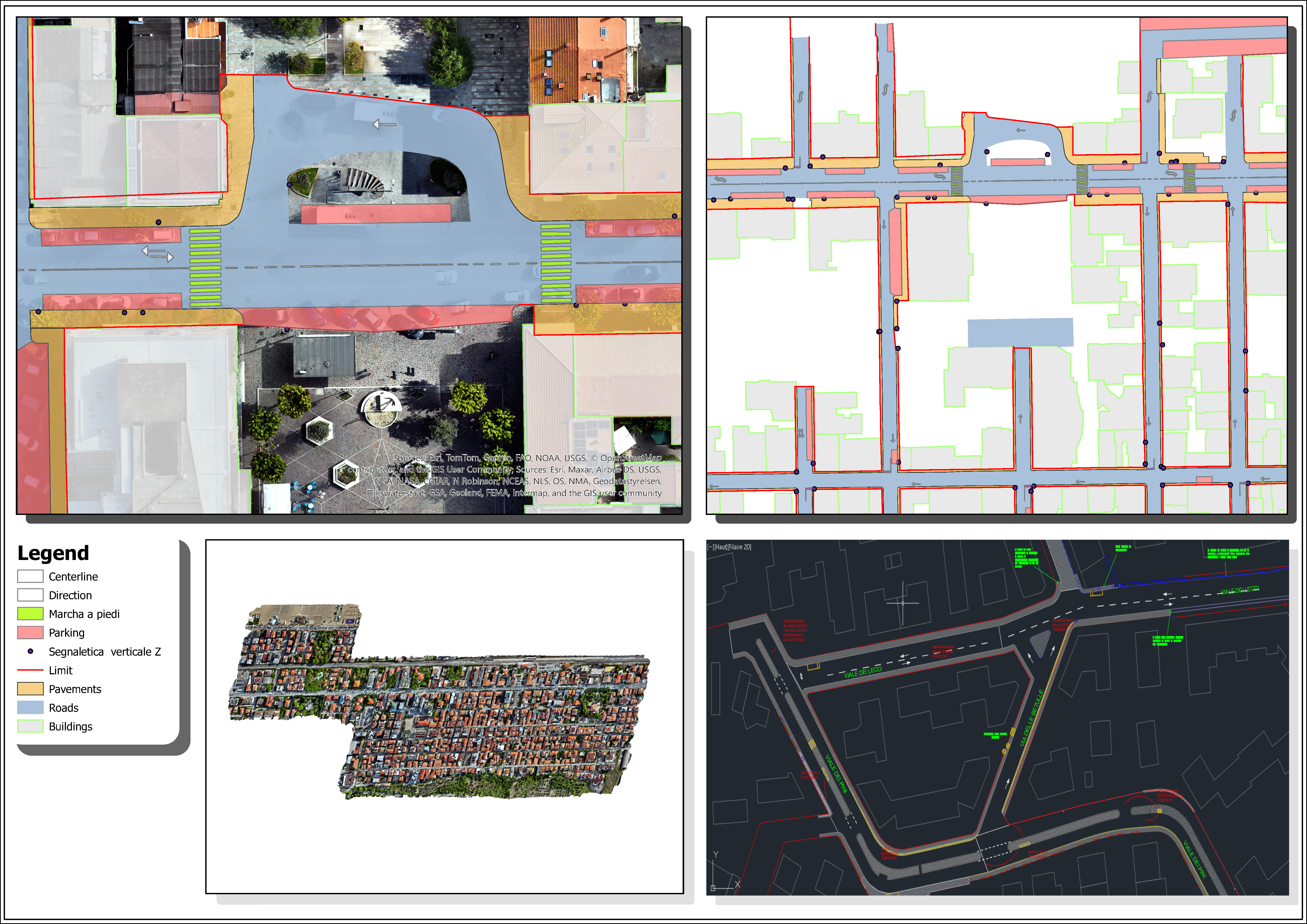
Digitized urban features over drone imagery
Cartography | GIS

Digitization & QGIS Plugin Development

I digitized cadastral maps from drone imagery across 40+ municipalities and developed a PyQGIS plugin that automated bulk attribute editing.

QGIS | Python (PyQGIS) | Drone Imagery | QA/QC

40+ municipalities digitized ~20% faster workflows Sub-meter accuracy

Snapshot

  • My role: I performed the digitization and designed, developed, and delivered the QGIS plugin.
  • Context: Engineering firm running a multi-municipality cadastral mapping program (client details withheld).
  • Scale: 40+ municipalities, large-volume drone imagery, sub-meter positional target.
  • Technologies: QGIS, PyQGIS, drone imagery, QA/QC workflows.

Challenge

An engineering firm needed rapid, accurate digitization of cadastral maps over drone imagery — with results that had to slot straight into existing GIS workflows and hold up to sub-meter accuracy requirements.

Technical approach

  • I digitized cadastral and urban features from drone imagery, following strict QA/QC procedures.
  • I developed a QGIS plugin that applies multiple rule-based conditions simultaneously to bulk-update attributes on large datasets.
  • I integrated Python batch-processing scripts for vector layers to cut repetitive editing steps.

Deliverables & validation

  • Clean digitized layers for 40+ municipalities, plus a reusable, adaptable plugin retained for future projects.
  • Each batch passed visual inspection and spatial-accuracy checks against reference imagery before delivery.

Results

  • Digitized 40+ municipalities
  • Cut processing time by about 20% compared with fully manual workflows
  • Held sub-meter spatial accuracy consistently across batches
  • The plugin remains reusable for future mapping programs

Why it transfers

This project shows both production speed and tooling judgment: when the manual workflow was slow, I built the tool that fixed it — and the tool outlived the project.

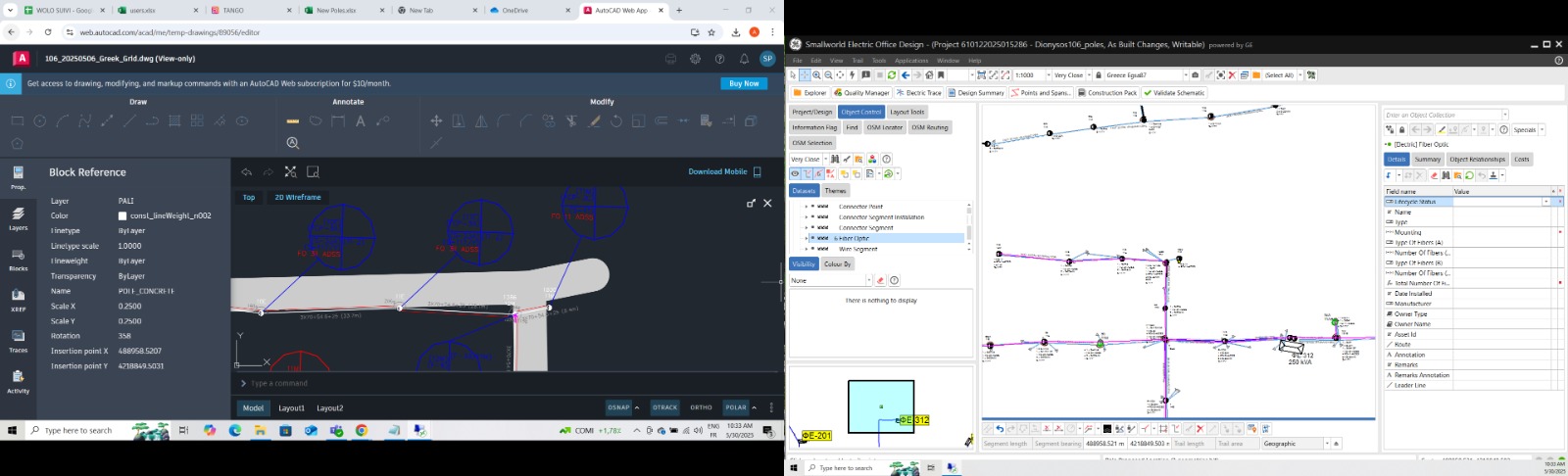
Fiber-optic network route data in Smallworld GIS
Fiber Optic Networks

Fiber Optic & Infrastructure Network Management

I updated, integrated, and harmonized fiber-optic and electrical infrastructure data in Smallworld GIS for a network spanning 10,000+ km and 500,000+ connections.

Smallworld GIS | AutoCAD | Data Harmonization

10,000+ km network 500,000+ connections 98% data accuracy

Snapshot

  • My role: I updated and validated network data and coordinated its alignment with engineering plans.
  • Context: Telecom infrastructure client managing fiber and electrical assets in Smallworld GE (details withheld).
  • Scale: 10,000+ km of network; 500,000+ connections across fiber-optic, electrical cables, and poles.
  • Technologies: Smallworld GIS, AutoCAD.

Challenge

The client managed more than 10,000 km of fiber-optic and infrastructure assets that had to stay compliant with AutoCAD engineering plans and evolving project requirements — across fiber, electrical cables, and poles.

Technical approach

  • I updated and integrated fiber-optic and infrastructure data in Smallworld GIS, working from AutoCAD plans.
  • I coordinated with cross-functional teams to keep network data aligned with project requirements.
  • I participated in project follow-up meetings and client discussions to resolve technical issues early and keep specifications clear.
  • I cross-validated GIS data against AutoCAD plans and technical specifications to protect accuracy.

Deliverables & validation

  • A unified, harmonized GIS dataset covering fiber-optic cables, electrical cables, and poles.
  • Systematic cross-checks against AutoCAD plans kept the dataset at 98% accuracy.

Results

  • Managed 500,000+ infrastructure connections (fiber-optic, electrical cables, poles) at 98% accuracy
  • Harmonized previously scattered data into one accessible network database
  • Improved data reliability for planning and maintenance teams

Why it transfers

Infrastructure operators depend on network data quality every single day. I know how to keep massive utility datasets accurate, current, and aligned with engineering source documents.

Freelance GIS Services

Alongside full-time roles, I take on selected freelance mandates — same standards, same rigor.

As a specialized GIS Analyst, I offer freelance consulting and technical services to organizations worldwide, with hands-on experience in the mining sector. Whether you need help with a specific project or ongoing support, I turn complex spatial data into reliable, actionable results.

📊

Spatial Analysis

Advanced geoprocessing, statistical analysis, and spatial modeling to solve complex problems.

🗺️

Custom Cartography

Professional map design for reports, presentations, and publications with high attention to detail.

⚙️

GIS Automation

Developing Python scripts and tools to automate repetitive workflows.

Have a project in mind?

Get a Quote

Career Journey

2025
Team Leader — Geodatabase Design & Integration
Led a team designing and implementing a municipal spatial geodatabase from custom data dictionaries. I managed data modeling in ArcGIS Pro, integrated deliverables, and developed the Python scripts and geodatabase rules that automated validation — cutting data-entry errors by 90% and enabling reliable multi-user editing on SQL Server.
2025
LiDAR Processing — MicroStation & TerraScan
Processed multi-mission LiDAR point clouds end to end: automated preprocessing with MicroStation macros, standardized ground, vegetation, and building classification in TerraScan, and scripted LAS splitting, validation, and merging with Python (laspy) — delivering high-precision DTM/DSM products with approximately 95% classification accuracy in validation checks.
2024
Fiber Optic & Infrastructure Data Management — Smallworld GE
Updated and integrated fiber-optic and electrical infrastructure data in Smallworld GE for a 10,000+ km network. I coordinated with cross-functional teams to align the data with AutoCAD plans, participated in follow-up meetings and client discussions to resolve technical issues early, and helped keep 500,000+ connections accurate and ready for planning.
2024
Digitization & Rectification — Drone Imagery
Digitized and rectified engineering plans from drone imagery, applying rigorous QA/QC procedures that protected data integrity and held sub-meter spatial accuracy across a 40+ municipality mapping program.

Skills & Expertise

Geospatial Database Design

ArcGIS Pro
SQL Server
SQL
Geodatabase Design
Domains & Subtypes
Arcade Attribute Rules
Versioned Editing
ETL
Data Migration

Applied in: municipal geodatabase with ~100 feature classes and 90% fewer data-entry errors.

GIS Automation

Python
PyQGIS
laspy
Python Toolboxes
Batch Processing
Workflow Automation

Applied in: geodatabase ETL, LiDAR pipelines, and the QGIS bulk-edit plugin.

LiDAR, Photogrammetry & 3D Data

TerraScan
MicroStation
LiDAR Classification
DTM/DSM Production
Metashape
Dense Point Clouds
Orthomosaics
Stereo Plotting

Applied in: multi-mission LiDAR classification and DTM/DSM production; photogrammetry trained on Metashape.

Network GIS & Infrastructure

Smallworld GIS
Fiber-Optic Networks
AutoCAD Integration
Infrastructure Data Harmonization

Applied in: 10,000+ km of fiber and electrical network kept at 98% data accuracy.

Cartography, Digitization & QA/QC

QGIS
Drone Imagery
Digitization
Rectification
Spatial Accuracy
Quality Control

Applied in: 40+ municipalities digitized from drone imagery at sub-meter accuracy.

Education & Certifications

3D Photogrammetric Restitution

Wolo Engineering 2023

- Hands-on experience in 3D restitution from stereoscopic aerial imagery
- Proficient in using the Topo Mouse for precise digitization
- Advanced stereo plotting and feature extraction techniques

Metashape Professional Training

Wolo Engineering 2022

- Localization and marking of GCP points for accurate georeferencing
- Creation and processing of dense point clouds from aerial imagery
- Generation of high-resolution orthomosaics for precise mapping
- Advanced mesh generation and texture mapping techniques

National Engineer's Degree in Geomatics and Surveying

ESAT University 2021-2023

Specialized in digital cartography, topographic instrumentation, and GIS applications, combining theoretical knowledge with practical fieldwork for geospatial analysis and urban planning

Contact

Open to full-time GIS roles & selected projects

Whether you are hiring for a GIS role or have a spatial data project in mind, tell me what you need — I usually reply within 24 hours.

If you are looking for a GIS Engineer who can structure spatial data, automate repetitive workflows, and deliver reliable geospatial products, I would be glad to discuss how I can contribute.

Opens a pre-filled email in your own mail app — replies usually within 24h.